For many of its miles, the Santa Cruz River is a dry sandy bed inhabited by tough desert creatures and vegetation. From headwaters in the Sky Islands of southeastern Arizona to its confluence with the Gila River, it moves through mountain and desert terrain, flowing in some stretches with used and treated water supplied by humans. It is a tributary to the Colorado River—the workhorse of the West, and celebrity river of monumental dams and the pioneer front. The Colorado, for its part, flows, creeps, and rumbles downstream, until it peters out to little more than a trickle sinking into sand after humans have taken its water away, dividing it between treaty and compact for distribution across the West. The journeys of these two rivers are quite different, but the water in both meets the same fate.
in November 2018. ©Bill Hatcher 2018
In the mountains southeast of Patagonia, Arizona, a droplet underground follows the water it is part of. It moves through the subterranean mystery of alluvial deposits, where substrate left by rivers long ago is supported in part by water molecules filling in the spaces between. Movement in that water pulls the droplet to a place of emergence—a hillside where it burbles out, or a crack in the rock that it falls from, or a pool into which it disperses. Springs take many forms, but all are examples of groundwater becoming surface water, and so at its spring this water drop tumbles, bubbles, or falls. It joins a small horde of water flowing into and over a creek bed and becomes a part of the Santa Cruz River.
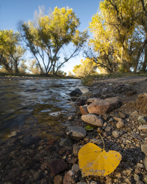
Almost all waterways in Arizona are ephemeral, meaning they will only flow after it rains, when a precipitation event drops enough water to run. Some waterways have intermittent flow in short sections as well; sinking below the surface as it trickles downstream, the water moves between layers of riverbed rather than over them, emerging briefly only to disappear again. The Santa Cruz is primarily ephemeral and intermittent like this. Through Arizona’s San Rafael Valley and across the USA-Mexico international border into Sonora, Mexico, the river has a naturally occurring flow for only short and variable stretches. Along these brief reaches, our droplet sparkles in the sun. One of a million water molecules shimmering along a riparian oasis, in and out of dappled shade created by tall leafy cottonwoods, weaving between stands of reeds. Over shallow rocks, the droplet harmonizes with birdsong and raptor cries, with the snuffles of javelina and silent padding of elusive wild cats.
It does not last long. The droplet sinks into the riverbed again, following the retreating bedrock below. Groundwater wells pop up in increasing number, pulling the water out from underneath the riverbed, and capturing our droplet in kind. Having taken a U-turn from a southern course to a northern one, the Santa Cruz River crosses the Mexico–U.S. border once more, passing by the wells that pump from the river’s aquifer to provide a large part of the water supply for Ambos Nogales, the sister cities of Arizona and Sonora. Pulled into the municipal system, the droplet moves through treatments, plumbing, and use, until ultimately it is flushed into the International Outfall Interceptor. This pipeline carries wastewater from the cities to be treated at Nogales International Wastewater Treatment Plant (NIWTP), just 9 miles north of the international border. Our droplet goes through a rigorous and highly effective treatment process to remove contaminants and is released once more into the Santa Cruz riverbed in an outpour of high-quality effluent, as the first of four perennially flowing stretches supplied and supported by humans, and seasonal stormwater, as with any ephemeral watercourse.
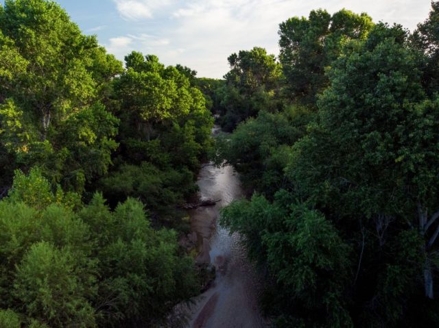
Along this stretch, the droplet is once again in the shifting sunlight that filters through leaf and branch, tumbling downstream in the river’s current. It glistens on wet river stones and is whirled around by the flicking tails of native fishes—the longfin dace and Gila topminnow, the latter an endangered species that was lost to this reach until 2015. There are non-natives too, and anyone who has walked along the banks of the Santa Cruz, whether running or dry, knows that there is inevitably a large amount of trash as well. The droplet moves through it all, with some difficulty at times. Past tree and bridge, beside volunteer trash surveys and cleanups by Friends of the Santa Cruz River and Tumacácori National Historical Park, under hawk and hummingbird. With any luck, that little droplet might make it close to Amado before it disappears again with its river. The flow from NIWTP has reached over 17 miles in the past, beyond Chavez Siding Rd, although with upgrades to the treatment plant in 2009 the river rarely flows so far now.
Through Green Valley and Sahuarita the now-dry riverbed winds, any remaining subflow deep below the surface with the far away bedrock. South of Tucson, near Martinez Hill, the bedrock rises to push subflow to the surface, but in the 1940’s the river that once flowed from here through modern-day Tucson was dried by the city’s multiplying wells. Tribal water settlements have now returned irrigation capacity to the San Xavier District of the Tohono O’odham Nation, resulting in runoff that has helped to recharge local groundwater. Flow has been rediscovered, but it does not reach the city. Our droplet’s story is picked up instead in downtown Tucson by a distant cousin. A far-away relative with the same ultimate goal, but a very different origin.
Part two is featured here.
Written by: Madeleine Oliver.